
Barndominium · DE
Barndominiums in Delaware
Delaware is the second-smallest state in land area, but a barndominium site here can fall on either side of a real geological line. The Delaware Geological Survey places all of northern New Castle County's hills in the Appalachian Piedmont and everything else — the rest of New Castle County plus all of Kent and Sussex counties — in the flat Atlantic Coastal Plain. That line, not the state's size, is what actually changes grading, drainage and foundation planning for a barndominium here, and because the whole state is compact, it is common for one buyer to be weighing a rolling New Castle County lot against a flat Sussex County farm parcel in the same search.
The intersection
What a Delaware site actually changes about a barndominium
The building program does not change because it is Delaware. The ground it sits on does, and Delaware has two genuinely different kinds of ground packed into a very small state.
The Delaware Geological Survey is specific about this: the entire state lies within just two physiographic provinces, the Appalachian Piedmont and the Atlantic Coastal Plain, separated by the Fall Line. Only the hills of northern New Castle County fall in the Piedmont; the rest of New Castle County and all of Kent and Sussex counties sit in the low-relief Coastal Plain. For a barndominium, that is the difference between a lot that may need real grading and drainage design and a lot that is close to flat before you touch it — and in Delaware, both are within a short drive of each other.
The state's small footprint amplifies this. At 1,948.5 square miles measured by the 2010 Census, Delaware is the second-smallest state in the country. A barndominium buyer here is not choosing between distant regions with different climates; they are frequently choosing between a rolling New Castle County parcel and a flat Kent or Sussex County parcel inside a single, compact search radius, so it is worth being explicit with a designer about which physiographic province the lot sits in rather than assuming 'Delaware' describes one type of site.
Because a barndominium is a residence, not just a workshop, the exposure questions that matter most are hazard-related rather than purely structural. FEMA's National Risk Index (hazards.fema.gov) publishes county- and tract-level exposure scores across 18 hazard types, including coastal flooding and hurricane categories that are directly relevant to a low-lying, low-elevation coastal state. This page does not state a hazard score for any Delaware parcel — that number is parcel-specific and changes with elevation and flood-zone mapping — but it is the correct starting point before you fix a floor elevation or a foundation type.
Site context
How a Delaware building site differs by province and county
Three practical zones cover most Delaware barndominium sites, and they behave differently before a single wall goes up.
Northern New Castle County (Piedmont)
The only part of Delaware in the Appalachian Piedmont, per the Delaware Geological Survey. Expect more topographic relief than the rest of the state, which means grading, retaining and drainage design are worth resolving before the floor plan is finalized.
Southern New Castle County and Kent County (Coastal Plain)
Low-relief Coastal Plain terrain. Kent County had 770 farms on 187,248 acres in 2022, with land in farms up 3% since 2017 — a sign that agricultural land here is still actively worked, which matters if a barndominium site is being carved out of a working parcel.
Sussex County (Coastal Plain, largest farm base)
Delaware's largest county by farmland: 1,053 farms on 262,079 acres in 2022, with 32% of farmland-in-use acres reported irrigated. A Sussex barndominium site is often adjacent to or carved from active, irrigated farmland, which affects well placement, setback conversations and shared access roads.
Exposure
Coastal hazard and rainfall are the recurring Delaware planning items
Between a low-lying coastal state and roughly 45 inches of annual precipitation at Wilmington, water management is the detail that recurs across almost every Delaware barndominium site.
NOAA's 1991-2020 climate normal for Wilmington's New Castle County Airport station puts annual precipitation at about 45.3 inches with roughly 20.2 inches of annual snowfall. That is a station normal, not a design value for any specific parcel, and nothing here converts it into a load or a permit answer. What it does support is a planning habit: finished floor elevation relative to surrounding grade, gutter and downspout routing, and where roof water discharges are worth deciding before the slab is poured, especially on the flatter Coastal Plain sites where water has fewer places to go.
The hazard side is a separate, parcel-specific question best answered through FEMA's National Risk Index rather than assumed from the state's coastline. A barndominium's residential use — living space, not just storage — makes flood-zone elevation requirements and evacuation-route access worth raising with your local building department early, since those answers vary by tract even within one county.
- Finished floor elevation
- Confirm it relative to surrounding grade and any mapped flood zone before the foundation type is fixed.
- Roof water routing
- Decide gutter and downspout scope up front on Coastal Plain sites where surface drainage is slower.
- Hazard data source
- Use FEMA's National Risk Index by county/tract rather than a general assumption about a coastal state.
Get Delaware barndominium quotes
Tell us which province your site sits in, whether it borders active farmland, and your rough footprint. We route it with the Delaware and barndominium context already attached.
Configuration
What Delaware barndominium projects are usually built around
The province a site sits in, more than a generic style preference, tends to shape which configuration a Delaware buyer actually needs.
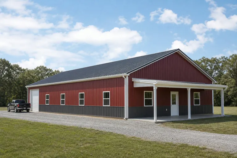 Coastal Plain farmstead residenceA living space attached to or paired with equipment storage on a working Kent or Sussex parcel; access and shared-drive logistics with active farmland matter here.Piedmont hillside homeA residence sited to work with New Castle County's rolling ground rather than against it, where grading cost is a real early variable.
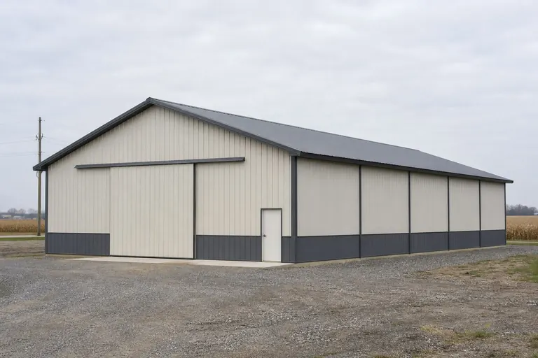 Shop-plus-living hybridA partitioned building splitting workshop and residential space, common where the buyer is also running equipment or a small operation from the same parcel.
Example Configuration — for planning purposes only.
Footprint
Footprints that suit a Delaware residential build
Flat Coastal Plain ground rarely forces a narrower footprint, which is why Delaware residential enquiries tend to favor width over length compared with a sloped-site state.
30′ × 50′
1,500 sq ft
A compact residential footprint that still separates living space from a small shop end.
40′ × 60′
2,400 sq ft
The common choice for a full living space with an attached garage or shop bay.
40′ × 80′
3,200 sq ft
Where a Sussex or Kent County buyer wants living space plus real equipment storage under one roof.
Example Configuration — for planning purposes only.
Footprint pages carry the layout and door detail for each of these; this page only explains why Delaware briefs land in this range.
Preparation
Before you request a Delaware barndominium quote
Four things resolved in advance make the difference between a comparable quote and a re-quote.
Step 1
Confirm your physiographic province
Tell your builder whether the parcel is in the Piedmont hills of northern New Castle County or the Coastal Plain; grading assumptions differ.
Step 2
Pull FEMA National Risk Index data for your tract
Coastal flood and hurricane exposure is parcel-specific; do not assume a single statewide answer.
Step 3
Contact your local building department
Floodplain elevation requirements, setbacks and permit thresholds are set locally, not at the state level.
Step 4
Describe any adjacent working farmland
Shared access, well placement and irrigation infrastructure on Sussex and Kent parcels can affect siting.
Questions
Delaware barndominium questions
Questions we can answer honestly at state level, with the ones we cannot routed to whoever actually owns them.
Delaware's small size means most sites sit either in the Coastal Plain (most of the state) or the Piedmont hills of northern New Castle County, and both are workable for a barndominium. The better question for your specific parcel is which province it falls in, since that changes grading and drainage planning.
It depends entirely on the parcel. FEMA's National Risk Index provides county- and tract-level hazard scores including coastal flooding, and your local building department can tell you whether your specific site falls in a mapped flood zone and what that means for floor elevation.
There is no official typical size. Flat Coastal Plain ground, which covers most of the state, tends to support wider single-story-friendly footprints in the 30x50 to 40x80 range without the grading cost that a sloped site elsewhere might add.
Permit requirements are set locally and depend on your county, your parcel and the residential use. Your local building department is the only reliable source; we do not state permit thresholds on this page.
We do not publish state-level prices, since a credible number depends on your specification, site work and current material pricing. Our cost pages cover what drives the number; a quote covers your building.
It can. Sussex County alone has 1,053 farms on 262,079 acres with 32% of farmland-in-use irrigated, so a parcel adjacent to active agriculture may involve shared access roads, irrigation infrastructure or setback conversations worth raising with the seller and your local planning office before you finalize siting.
Sources for the Delaware facts on this page
This page states no code requirement, wind speed, snow load, permit rule, price or supplier claim. The state-specific facts it does use are listed with their publisher below.
The Delaware Geological Survey states the entire state lies within two physiographic provinces, the Appalachian Piedmont and the Atlantic Coastal Plain, separated by the Fall Line; only the hills of northern New Castle County lie within the Piedmont, with the rest of the state in the low-relief Coastal Plain.
Delaware Geological Survey, University of Delaware · DGS reference material · Tier 2
https://www.dgs.udel.edu/delaware-geology/summary-geologic-history-delawareDelaware's total land area was measured at 1,948.5 square miles as of the 2010 Census, the second-smallest of any U.S. state.
U.S. Census Bureau · 2010 Census · Tier 1
https://www.census.gov/geographies/reference-files/2010/geo/state-local-geo-guides-2010/delaware.htmlFEMA's National Risk Index platform (hazards.fema.gov) is the authoritative county/tract-level source for Delaware natural hazard exposure scores across 18 hazard types, including coastal flooding and hurricane categories relevant to a low-lying, low-elevation coastal state.
Federal Emergency Management Agency (FEMA) · Current NRI dataset · Tier 1
https://www.fema.gov/flood-maps/products-tools/national-risk-indexSussex County, Delaware's largest county by farmland, had 1,053 farms on 262,079 acres in 2022, with 32% of farmland-in-use acres reported irrigated.
USDA NASS · 2022 · Tier 1
https://www.nass.usda.gov/Publications/AgCensus/2022/Online_Resources/County_Profiles/Delaware/cp10005.pdfDelaware had 2,158 farms in 2022, covering 522,834 acres of land in farms, an average farm size of 242 acres.
USDA National Agricultural Statistics Service (NASS) · 2022 · Tier 1
https://www.nass.usda.gov/Publications/AgCensus/2022/Online_Resources/Congressional_District_Profiles/cd1001.pdfWilmington's 1991-2020 annual climate normal precipitation is about 45.3 inches with roughly 20.2 inches of annual snowfall.
NOAA National Centers for Environmental Information (NCEI) · 1991-2020 · Tier 1
https://www.ncei.noaa.gov/access/services/data/v1?dataset=normals-monthly-1991-2020&dataTypes=MLY-PRCP-NORMAL,MLY-SNOW-NORMAL&format=csv&stations=USW00013781